In the Caucasus, among the majestic beautiful rocky mountains, many fast rivers flow. One of them will be described in more detail in this article.
general information
Psou is a river dividing the territory of Abkhazia and Russia. It flows along the entire border line between states. Translated from the Abkhazian language, its name means “long river”, although in reality this does not quite correspond to the truth. Its total length is only 53 kilometers.
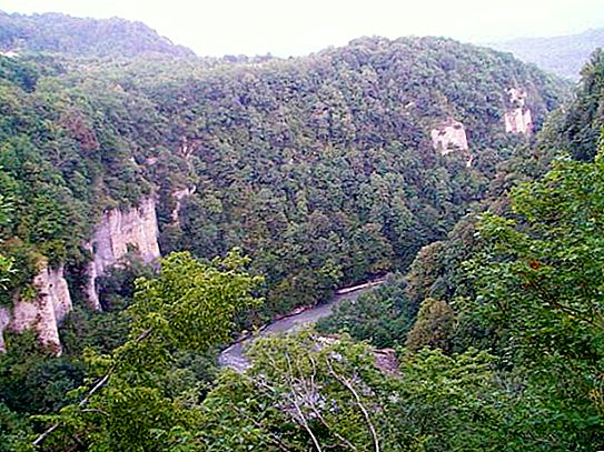
The banks of this fast mountain river are covered with amazingly beautiful green forests and diverse vegetation.
The river belongs to the territory of the Western Caucasus. Psou, as noted above, has a special and important task - it forms the water border between the two states, namely, between the Russian Krasnodar Territory and the Gagra region of Abkhazia.
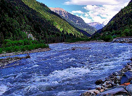
Its source is high in the mountains (Adepsta slope), and the mouth of the Psou River is near the Black Sea itself. The total basin area is approximately 421 square kilometers. The river flows along the eastern outskirts of the resort city of Sochi (Adler District).
A Brief History of the Psou River Border
Psou is a river that until 1920 had not yet performed the border function. Until the middle of the 19th century (until 1864), it flowed along the central part of the Sadz land (one of the West Abkhaz ethnic groups). Its upper reaches were located on the territory of another free Abkhaz settlement - Aibga.
Immediately after the war ended, the Western Abkhazians were evicted in Turkey, and on the liberated lands in 1866 the Black Sea District was formed, the borders of which ran from the city of Tuapse to Bzybi.
This district in 1896 was transformed into the Black Sea province, which lasted until the very October Revolution of 1917. All this time, the Psou River was an internal water stream and, again, did not carry out any border functions.
The troops of the Georgian Democratic Republic occupied the territory of Abkhazia in 1918. Due to the hostilities between the volunteer Denikin army and Georgian troops in the Sochi-Gagra region, the border of Abkhazia on the western side could not be determined for a long period of time. Only after Russia's short-term recognition of Georgia’s independence in 1920, an agreement was signed indicating the border along the Psou River.
Psou River: photo, description of the area
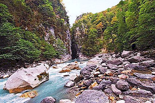
Despite the relatively small extent, the river is full of water and quite stormy. Like many other mountain rivers, it has a very fast current, forming numerous whirlpools. High rainfall in the western part of the Greater Caucasus provides full flow.
The Psou River (Abkhazia) begins not from the Main Range, but from its nearby spurs. These are the Ategert and Ayumga ranges. The upper reaches of the river are surrounded by the Thury Mountains. This is a rather harsh area with mountains formed by volcanic rocks. The upper slopes are densely overgrown with fir trees, and beech species appear a little lower, and then (even lower in the valley) - mixed forests with oaks and maples. Sometimes there are also fruit trees entwined with different types of vines (clematis, wild grapes, periploc, sassaparilla, etc.).
Food and tributaries
Psou is a river that feeds initially (at the source) with groundwater at the tops of the mountains. As the course proceeds, various tributaries join the Psou, which also (like precipitation) contributes to its full flow. The river, thanks to all of the above factors, becomes strong and powerful. It maintains the water level even in the hottest and sultry periods of the year.
In winter, the river does not completely freeze - only in places and only during the coldest days.
Due to the unique terrain, the right tributaries flowing into Psou from the Russian territory are more watery and longer than the left. Especially distinguished from them are such rivers as Bezymyanka, Glubokaya, Arkva and Mendelikh. From the side of Abkhazia, from the left tributaries, the Phista River can be distinguished.

Geography
The Psou channel runs almost parallel to the Mzymta River. However, unlike the second, Psou is a river flowing, as noted above, from the spurs of the Main Caucasian Range. First, it flows west, then northwest, and then, gradually turning to the left, forms a slightly shallow arc and goes south. It flows into the Black Sea near Adler. This is about eight kilometers from the mouth of the very river Mzymta.
The upper reaches of the Psou River are surrounded by the Thury Mountains, formed by granite, limestone and volcanic rocks. These are very high mountains (the peak of Azituko reaches a height of 3, 230 meters).

Microdistrict Veseloe-Psou
This original name belongs to one of the microdistricts located in the Adler district of Sochi. The village is a cozy resort town, where thousands of tourists come annually. It was not named so by accident, because the eastern border of the region runs along the river of the same name.
The village consists mainly of private buildings. Of course, there are a small number of multi-storey modern buildings. The infrastructure of the microdistrict is quite developed - there are shops, a school, a kindergarten and a clinic.


