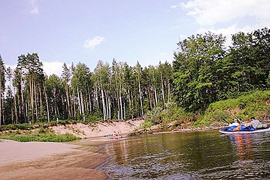
The Republic of Udmurtia is one of the constituent entities of the Russian Federation located in the western part of the Middle Urals. The region has a dense and well-developed hydrographic network. One of the largest rivers in Udmurtia is Kilmez. It is about her that will be discussed in this article.
General description of the Kilmez river
Kilmez is the second largest tributary of the Vyatka, flowing into the mother river on the left side. The watercourse belongs to the Volga basin and flows through the territory of two regions of Russia - Udmurtia and the Kirov region.
The Kilmez River is a classic example of a flat watercourse with a wide but shallow valley. Here are its main hydrological characteristics:
- Length: 270 km.
- Width: from 20 to 50 m.
- Depth: from 0.4 to 2.5 m.
- Pool area: 17 525 sq. M. km
- Water consumption in the cross section of the channel (average): 84.6 m 3 / s.
- Channel slope (average): 0.4 m / km.
- The speed of the current: 0.5-1 m / s.
The etymology of the hydronym Kilmez is not fully understood. Researchers attribute its origin to either the Kildin kelmas (“cold”) or the Mari “kylme” (“frozen”). However, the semantics of both of these words are similar.
Nowadays, the Kilmez River is used by man for alloying wood, and also has important fishing significance. Pike, ide, pike perch, burbot, bream, roach, perch are found in its waters, grayling and rudd are found in the tributaries. Kilmez is navigable for 75 kilometers from its mouth. In recent years, water tourism has developed on the river.
The source and mouth of Kilmezi
Kilmez originates on the Krasnogorsk Upland, within the so-called Holy Highlands. It is a hilly and dull area where several large watercourses arise among forests and swamps: Salya, Ubyt, Lekma, and Ut - one of the tributaries of Kilmezi. The source of the river is marked on the ground with a 6-meter pagan idol made from an age-old pine by the Krasnogorsk craftsman Peter Zakharov.

Kilmez flows mainly in the south-western direction, taking in, on the left and right, a number of large tributaries. The river bed is quite winding, the bottom is composed of sand, gravel and pebbles. The upper and middle reaches of Kilmesi are administratively located within Udmurtia, while the lower reaches are in the neighboring Kirov region.
The Kilmezi river basin can be divided into two parts: right-bank and left-bank. The right bank is a lowland plain with a fairly high percentage of wooded area. The left bank of Kilmezi is a raised and strongly dissected plain, which is a genetic continuation of the Kama Upland. Accordingly, the left bank near the Kilmezi valley is steep, and the right one is more gentle.
Kilmez flows into Vyatka near the village of Ust-Kilmez, Urzhum district, Kirov region. At the same time, the river forms several steep meanders and elders in the estuary.
On the banks of Kilmezi there are a number of towns, villages and villages. The largest settlements (from source to mouth):
- Malyagurt.
- Arlet.
- Vinyashur Biya.
- Pumsey.
- Kilmez (Udmurtia).
- Kilmez (Kirov region).
- Krasny Yar.
- Trinity.
- Selino.
Main tributaries
The Kilmez River has at least 25 large tributaries. We list and briefly describe the largest of them:
- Arlet (51 km) is a left tributary, flows into Kilmez near the village of Magistralny. It features a smooth flow and a small channel width (up to 15-20 meters).
- Ut (107 km) is the right tributary of Kilmezi, the source of which is also located on the Krasnogorsk Upland. At first it flows in a westerly direction, but then abruptly turns to the southeast. The Ooty basin is almost continuous spruce-birch forests.
- Lumpun (158 km) is a right tributary that flows into Kilmez near the village of the same name in Udmurtia. The river is characterized by great tortuosity; in the lower reaches, its channel is complicated by numerous meanders, backwaters and elders.
- Vala (196 km) is the left tributary of Kilmezi. Most of the channel is in Udmurtia, although the mouth of the river is already in the Kirov region. Vala is known for significant seasonal fluctuations in water levels (up to 5-6 meters).
- Loban (169 km) is the right tributary of Kilmezi. The valley of this river is very swampy and practically uninhabited by humans.


