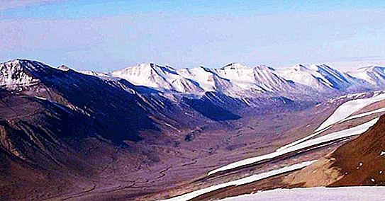
There is a place on Earth that is so unlike any other that it was used to test equipment that was supposed to go to Mars. The Dry Valley region of Antarctica is one of the most extreme deserts in the world. And this is not its only feature.
Victoria Land in Antarctica, on which they are located, was discovered in 1841 during the Ross expedition. She was named after the Queen of England.
Where are
The dry valleys of icy Antarctica are a very unusual part of the mainland, they were formed due to the location of the Transantarctic Range, which makes air flow above them. Because of this, they lose moisture, and snow and rain do not fall there. The mountains also prevent ice from flowing down the valleys from the East Antarctic ice sheet, and finally, strong katabatic winds (downward) play a role, blowing at a speed of up to 320 km / h. This is one of the most extreme climates on the planet, a cold desert, where the average annual temperature ranges from -14 ° C to -30 ° C, depending on the place, while it is warmer in windy places.
They cover an area of about 4800 square kilometers and, located at a distance of about 97 kilometers from McMurdo station, have been the place for many studies for many years in connection with a number of related phenomena.
Discovery story
There are three large valleys here: Taylor Valley, Wright Valley and Victoria Valley. The first was discovered during the expedition of Robert Scott "Discovery" in 1901-1904. She was then examined in detail by Griffith Taylor during Scott's later Terra Nova expedition in 1910–1913. In honor of him, she received this name. The valley is surrounded by high mountain peaks, and at that time no further study of the surroundings was conducted. It was only in the 1950s that new valleys and their sizes were identified in aerial photographs.
There is a lake in the Taylor Valley, which may have become a kind of myth. It was officially named after Lake Chad in Africa, which in the local language means "large expanse of water." According to legend, when a group from the Scott expedition 1910-1913. located nearby, they took, as they believed, clean drinking water from it. But as a result, all members of the expedition suffered from terrible diarrhea, and, accordingly, a large amount of toilet paper was used. Its trade name was Chad, which is where the name of this lake came from. The cause of the disease was toxic chemicals that are produced by cyanobacteria found in and around the pond.
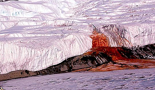
Bloody waterfall
It was first discovered by Griffith Taylor during the Scott Terra Nova expedition in 1911. The reddish-brown color of the water, which caused this name, is due to the presence of iron oxide, and not to algae, as originally assumed. This compound is located in a lake under the Taylor Glacier, where the unusual chemical composition of water allows chemoautotrophic bacteria to survive without any sunlight or organic molecules from the outside.
They absorb a large number of iron ions II (Fe2 +) and sulfate (SO4-) coming from the underlying rock, and oxidize them to iron III ions (Fe3 +), releasing energy. A large and very salty lake is sometimes overflowing, which leads to the appearance of Bloody Waterfall.
Mummified Seals
This is another oddity of the Antarctic Dry Valleys. Moreover, the mummies of these animals are many kilometers from the sea. Usually these are Weddell seals and crab eaters, found at a distance of 65 km from the sea and at an altitude of one and a half kilometers. The dating was carried out using carbon, as a result it turned out that their age is from several hundred to 2600 years.
It seems that they died relatively recently. Cold winds quickly dry out the carcass and lead to mummification. The younger ones (about one hundred years old) are very well preserved. Sometimes they find themselves in lakes, which may be subject to seasonal melting, which accelerates their destruction. No one knows for sure how or why these seals ended up in the center of the Antarctic Dry Valleys.
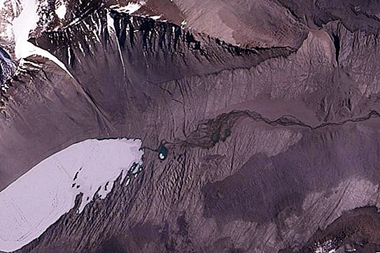
Onyx River
Another surprise of this region. It is the longest river on this continent, although, in fact, it is just a seasonal stream of meltwater.
It forms in the summer, coming from the lower Wright glacier, and flows into the valley of the same name for 28 km until it reaches Lake Wanda. The flow is very variable depending on the temperature. In the summer, it rises for several weeks, part of the glacial ice begins to melt and flows into the Dry Valleys of Antarctica. Onyx usually flows for 6-8 weeks, in some years it may not reach Lake Wanda, while in others it leads to flooding, causing significant erosion of the bottom of the valley. This stream reaches a depth of up to 50 cm and can be several meters wide; it is one of the largest, consisting only of glacial melt water.
Don Juan Lake
This is one of the most interesting reservoirs on earth. It is the most saline natural body of water on the planet. The salinity of the lake is more than 40% (1000 g of water in it contains 400 g of dissolved solids). This is 34% higher in the Dead Sea than in the oceans (average salinity 3.5%). In 1961, he was discovered by two helicopter pilots Don Rowe and John Hickey, who were surprised by the fact that this lake did not freeze at a temperature of -30 ° C. It turned out - because of such an amount of salt in the water.
It was found that it was formed from atmospheric water and a small amount of melted snow. Salts in surrounding soils near the surface absorb any water present in the air or ground, which then dissolves in it. This concentrate flows into the lake. After that, part of the water evaporates, and the salts are concentrated. 90% of them are calcium chloride (CaCl 2), and not sodium chloride (NaCl), as in the world's oceans.
Maze
Dry valleys reveal the bedrock of Antarctica and have almost no erosion and are not covered by plants. Therefore, their geological features are well preserved and, in most cases, are clearly visible. One of the biggest and most striking of these features here is the region known as the “labyrinth”. It consists of a series of channels carved into a rock layer 300 m thick with a total length of about 50 km. Their width is 600 m and the greatest depth is 250 m.
Its features indicate that for some time meltwater passed in huge quantities here. The date of the last stream (there could be several) is determined between 14.4 and 12.4 million years ago. It is believed that the channels of the labyrinth were most likely destroyed as a result of the occasional drainage of huge lakes that are under the ice sheet of East Antarctica.