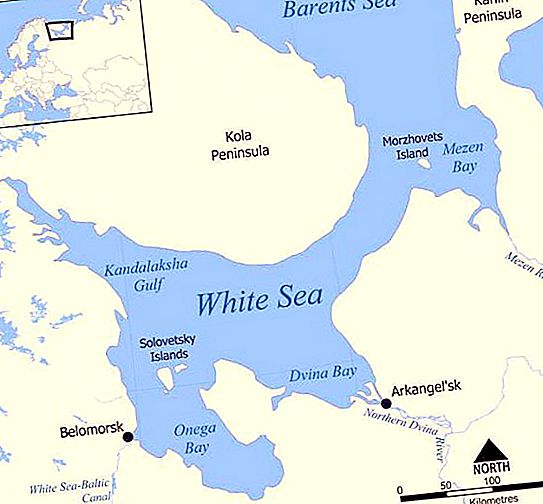
Where is Kandalaksha Bay located? It is located in the northwest of the White Sea, between the southern coast of the Kola Peninsula (Kandalaksha coast) and the coast of Karelia. The length of this water area is 185 km, and the width at the entrance is 67 km. The shores of the bay, formed 10 thousand years ago, after the retreat of the glacier, are heavily indented with small fjords (lips), in the water area there are hundreds of small skerries and numerous underwater cliffs.
Characteristic
In Kandalaksha Gulf is the deepest place of the White Sea. A depth of 200 meters extends into the bottom from the sea. This place reaches almost the middle of the bay. In the western part of this depression is the deepest basin (343 m). However, such depths are more an exception than a rule. The average size of this water area is about 20 m, offshore it decreases slightly and reaches up to 10 m. Shallow water littoral - this is how the Kandalaksha Bay can be characterized. Tides, as a rule, are 1.8-2 m in size, but there are also those that reach 3 m. The tidal wave comes from the White Sea Throat, spreading to the south and west. In summer, the water temperature on average reaches 14-15 ° C, in small protected bays, the water can warm up to 25 ° C.
Climatic features
The climate of the bay is very unstable, the weather changes dramatically due to the movement of cyclones and frequent changes in wind direction. The influence of the Gulf Stream is less pronounced in this area than on the Murmansk coast. The average temperature in July is 13-14 ° С, in February - from -10 ° С to -12 ° С. The period without frost lasts 110-120 days. Kandalaksha Bay is covered with ice in the cold years already in mid-October, in the warm ones - in December and even in early January. Melting usually occurs in May.
Coast development
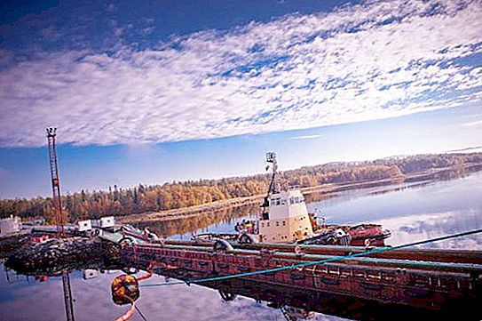
The Kola Peninsula area was inhabited by people shortly after the glacier melted - in the 7th-6th millennia BC. e., in the Mesolithic era. On the coast of the bay, the oldest archaeological sites date back to the Early Iron Age. Silver was mined on the Medvezhy Island in the XVII-XVIII centuries, but its reserves were small. Industrial development began after the construction of the Murmansk Railway in 1915-1916. Active logging took place along the shores in 1910-1938. Today, an important transport route passes through Kandalaksha Bay, through which oil and other cargoes are transported. The large port of Kandalaksha is located on the western tip of the water area.
Neighborhood
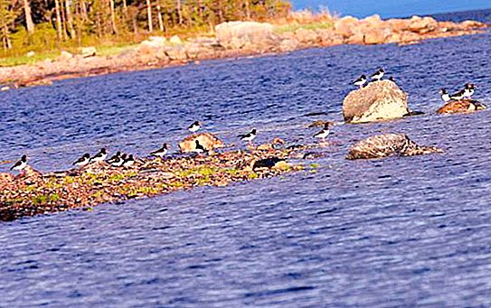
In 1932, the Kandalaksha Reserve was created in the water area of the bay and on the islands to protect the massive nests of the eider. Subsequently, the size of protected areas increased, reaching by now 70 thousand hectares. Hunting in the water was banned in 1957. Among the natural monuments of the coast and islands are exits to the surface of the earth of the oldest rocks, 3 billion years old.
Features
The shores of the gulf are high and rocky, the average height of the cliffs of the Karelian coast is 100-300 m, and Kandalaksha - 175-600 m. The ebbs and flows in the Kandalaksha gulf are of a certain nature. The tidal current is from the White Sea. It moves north at a slow speed. If you follow its direction, it will lead to the eastern side of the Turia Peninsula. The ebb tide moves back tidal.
Vegetable world
The coast of the water area is mostly covered with coniferous forests (mainly pine), at heights alternating with low shrubs. More than 630 species of higher plants grow on the shores and islands, which makes up 55% of the entire flora of the Murmansk region. Kandalaksha Bay is located at the junction of two floristic regions - the North European and the Arctic. In the reserve, 25 endemic plants were identified, including Arctic sunflower, five species of bog orchids, two species of ferns, peony marin root. In addition, in the forests there are places covered with a venus slipper (up to two to three thousand copies in one area) and another rare type of orchid - leafless chin.