In modern science they talk about the relief and its main components: appearance, historical origin, gradual development, dynamics in modern conditions and special patterns of distribution from the point of view of geography, and also often mention endogenous and exogenous processes. It is a part of geography as a community and as a complex science that geomorphology can be considered, which, in fact, is characterized by the above definition. In this intra-geographical scientific branch, the concept of relief as the final product of the mutual influence of exogenous and endogenous geological processes dominates today.
Exogenous processes
Under exogenous processes are understood such geological processes that are caused by external sources of energy relative to the globe, combined with gravity. The primary sources of energy include solar radiation. Exogenous processes occur in the near-surface zone and directly on the surface of the earth's crust. They are presented in the form of physicochemical and mechanical interaction of the earth's crust with water and air layers. Exogenous processes are responsible in nature for destructive work in order to smooth out surface irregularities, which, in turn, are formed by endogenous processes, namely, the protrusions are cut off and relief cavities are filled with destruction products.
Endogenous processes
The globe is undergoing constant change. Endogenous and exogenous geological processes are antagonistic. They are able to cancel the influence of their opponent on Earth. Endogenous processes are geological processes that are directly related to the energy generated in the deep bowels of the solid earth's surface (lithosphere). The property of endogeneity is characteristic of many fundamental phenomena in the field of the formation of the earth's surface. Rock metamorphism, magmatism, and seismic activity are referred to endogenous. An example of endogenous processes is the tectonic movements of the earth's crust. The main sources of energy for this type of process are thermal, as well as material redistribution in the bowels in accordance with the density of certain materials (scientifically called gravitational differentiation). Endogenous processes are fueled (as the name implies) by the internal energy of the globe and are manifested primarily in the multidirectional movements of the enormous masses of rocks of the earth's crust, and with them the molten matter of the earth's mantle. As a result of endogenous processes, large irregularities are created on the earth's surface. It is these processes that are responsible for the formation of mountains and mountain ranges, intermountain troughs, and troughs of the oceans.
In the interaction of exogenous and endogenous variants of processes, the earth's crust and its surface develop. We will consider the design processes, that is, endogenous geological processes, which, in fact, create the largest parts of the earth's relief.
Endogenous groups
Among endogenous 3 groups of tightly interconnected, but independent processes are distinguished:
- magmatism;
- earthquakes;
- tectonic influences.
Let's take a closer look at each process.
Magmatism
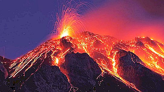
Endogenous processes include volcanic phenomena. Under them should be understood processes based on the movement of magma on the surface of the earth's crust and in its upper layers. Volcanism demonstrates to man that matter that is in the bowels of the Earth, scientists have the opportunity to get acquainted with its chemical composition and physical condition. Volcanic phenomena are manifested far from everywhere, but only in the so-called seismically active areas, to which, in fact, the possibility of such phenomena is confined. Territories with active or dormant volcanoes on them often underwent geological changes during the historical process. Magma, penetrating the internal endogenous processes of the Earth, may not even reach the surface, in which case it freezes somewhere in the bowels of the earth and forms special intrusive (deep) rocks (these include gabbro, granite, and many others). The phenomena that result in the penetration of magma into the earth's crust are called Platonism, and otherwise - deep volcanism.
Earthquakes
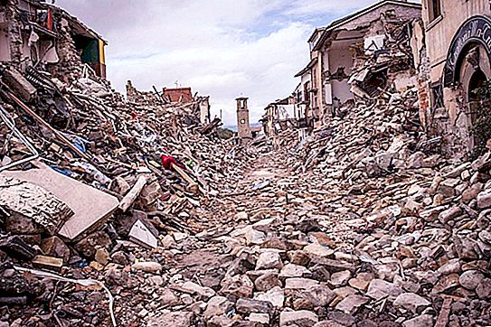
Earthquakes, which are also among the main endogenous processes, are manifested in certain areas of the Earth's surface, expressed in short-term shocks. It is clear to everyone that earthquakes, as natural disasters, along with volcanism, have always been close to human society, and as a result, they have astounded the imagination of people. Earthquakes did not pass without a trace for a person, causing his household (and sometimes even health and life) tremendous damage in the form of destruction of buildings, violation of the integrity of agricultural crops, severe injuries or even death.
Tectonic influences
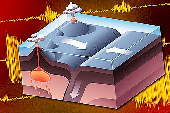
In addition to earthquakes, which are short-term and powerful fluctuations, the earth's surface experiences influences in which some of its sections rise, while others fall. Such movements of the cortex occur unimaginably slowly (in relation to the pace of our everyday life): their speed is equivalent to changes at the level of several centimeters or even millimeters per century. So they, of course, are inaccessible to observations of the human eye, measurements are requested only with the use of special measuring instruments. However, paradoxically, for the appearance of our planet, these changes are very significant, and on a historical scale, their speed is not so small. Since such movements take place constantly and everywhere for many hundreds, or even millions of years, their final results are impressive. Under the influence of tectonic movements (and they are called that way), many land areas have turned into a deep ocean floor, on the contrary, with the same success some parts of the surface, which now rise hundreds, thousands of meters above sea level, were once hidden under dense water cover. Like everything in nature, the intensity of vibrational movements is different: in some areas, tectonic processes are more rapid and have a greater impact, while in other places they are much slower and less significant.
In this article, we will focus on tectonic processes, since they are crucial in the field of relief formation, and hence the external appearance of our planet. So, tectonics determines the nature and plan of future outlines of the relief forms of the globe for many centuries.
Tectonic blocks
Let us once again denote that tectonic changes are understood as endogenous processes of formation of a relief image. Tectonics is directly related to the movements of special monolithic blocks, which are separate fragmentary parts of the earth's crust. It is important to understand that these blocks are different from each other:
- in thickness (minimum from a few meters and tens of meters, and a maximum of kilometers in the tens);
- by area (the smallest are tens and hundreds of kilometers squared, and the largest reach an area of millionths of an area);
- the nature of the deformation of the rocks that make up the earth's crust (again, we distinguish two types of changes: discontinuous and folded);
- in the direction of movement (there are two types of multidirectional movements: horizontal and vertical tectonic movements).
History of the development of tectonics
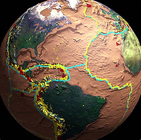
Until the middle of the 20th century, the concept of fixism was a leading position in geomorphology and geology. Its basis was the idea that the main, dominant type of oscillatory movements should be considered vertical, while the horizontal type of movement is secondary. Thus, geologists believed that all the largest forms of terrestrial relief (namely, ocean troughs and even entire continents) were created exclusively due to vertical movements of the crust. Continents were listed as zones of surface elevation, and oceans were perceived as zones of its subsidence. The same theory was explained, and it must be admitted quite understandably and reasonably, and the formation of smaller unevenness in the relief of the relief, namely, separate mountains, mountain ranges and separating these very ridges depressions.
However, as you know, ideas tend to change over time, and any truth can easily turn from an absolute status into a relative one. A geologist named Alfred Wegener focused the attention of the scientific community on the fact that the shape and shape of different continents in geometric terms are quite well combined with each other. At the same time, active work began on the collection of geological and paleontological data from various continents available for study at that time. These studies showed an interesting thing: on the continents located at distances equal to many thousands of kilometers from each other, absolutely identical creatures lived in the distant past, moreover, due to the structural features, many species of creatures had absolutely no way to cross incredibly large water spaces.
All the same, Wegener carried out invaluable work on the analysis of a huge amount of paleontological and geological data. He compared them with the outlines of the continents now existing, and according to the results of his research he expressed the theory that in the past life the continents on the Earth’s surface were completely different from what they are now. In addition to this, the scientist tried to make a unique reconstruction of the general view of the land of past geological eras. Let's talk about Wenger's theory in more detail.
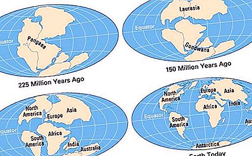
In his opinion, in the Permian period of the Paleozoic, on Earth there really existed one supermaterial of huge sizes, which was called Pangea. By the middle of the Jurassic Mesozoic, it was divided into two independent parts - the mainland Gondwana and Laurasia. Further, the number of continents steadily increased: Laurasia broke up into modern North America and Eurasia, and Gondwana, in turn, was divided into Africa, South America, Antarctica, Australia and Hindustan (later Hindustan became Eurasia). In fact, this is how the concept of fixism fell. It has become impossible to explain the changes in the outlines of the continents of such a plan and the further movements of the continents on the Earth's surface within the framework of this theory.
Wegener did not stop there. He fixed the collapse of fixism with the assumption that the continents, having taken the form of huge lithospheric blocks, do not move in the vertical, but in the horizontal direction. Moreover, it is horizontal movements, from his point of view, that are the main tectonic oscillations that had a decisive influence on the appearance of our planet. The theory of Alfred Wegener was called the theory of continental drift, and its adherents became known as mobilists (as opposed to fixists). Wegener might have been able to contribute to the study of other endogenous and exogenous geological processes, but he stopped at this stage.
Be that as it may, apart from the incompletely substantiated conclusions of Wegener himself and the paleontological data, there was no evidence of the validity of the continental drift series. In order to obtain data to confirm or refute the new theory and, finally, understand why the continents are moving, it was necessary to study the structure of the earth's crust more carefully. However, the second aspect of the work was a more important point: it was necessary to study the structure of the bottom of the oceans as completely as possible, until then not studied at all. Just imagine: according to the opinion that existed at that time among the vast majority of scientists, the ocean floor was a completely flat surface!
Continental and oceanic crust
These studies were conducted and gave completely unexpected results. To the surprise of scientists, the terrain of the Earth under the oceanic layer and under the continents was differently arranged.
The continental crust is powerful and consists of three layers:
- upper (formed by sedimentary rocks of the sedimentary layer, which is formed on the earth's surface);
- granite (next to the top);
- basalt (the two lower layers are formed by rocks born in the bowels of the earth as a result of cooling and further crystallization of mantle matter).
The crust at the bottom of the oceans is very different. It is thinner and consists of only two layers:
- upper (formed by sedimentary rocks);
- basalt (missed granite layer).
A real revolution took place: it became possible and, moreover, the existence of two different types of the earth's crust: the oceanic and the continental, was actually proved.
Mantle layer
Below the earth's crust is a mantle, the substance of which is presented in a molten state. The asthenosphere is a mantle layer located at a depth of 30-40 kilometers under the oceans and 100-120 kilometers under the continents. Judging by the speed characteristics of seismic waves, it is endowed with high ductility, and even such a property as fluidity. It should be understood that absolutely all layers above the asthenosphere represent the lithosphere. That is, the Earth's crust and the mantle layer above the asthenosphere enter into a peculiar lithospheric formula.
Ocean bottom relief
The topography of the ocean floor also turned out to be much more complicated than previously thought. Its main components are:
- shelf (a surface conditionally continuing the slope of the land of the mainland from the water edge to 200-500 meters of depth);
- continental slope (from the end of the shelf zone and up to 2.5-4 thousand meters, and possibly more);
- the basin of the marginal sea (a somewhat uneven (hilly) plain surface into which the continental slope flows through the continental foot, otherwise called the concave bend);
- island arc (a chain of volcanoes or volcanic islands under water, this bottom component separates the marginal sea from the open sea zone);
- deep-sea trench (the deepest part of the ocean floor, which is parallel to the island arc along the outer edge of the bottom, is a rather narrow and deep cleft);
- the bed of the ocean (outwardly resembles the hollow of the marginal sea, but much wider: several thousand kilometers, the bed is divided into two parts by an uplift that connects to the whole system with the concepts of other oceans (mid-ocean ridges are created);
- rift valley (in the elevated parts of the mid-ocean ridges, narrow and deep).