

The powerful Yenisei carries its waters to the Kara Sea (the outskirts of the Arctic Ocean). The official document (State Register of Water Objects) established: the source of the Yenisei River - the confluence of the Small Yenisei and the Big. But not all geographers agree with this point. Answering the question “where is the source of the Yenisei River?”, They indicate other places on maps, give different versions for measuring the length of the river and, as a result, other hydrological characteristics.
Some characteristics of the Yenisei
According to hydrogeological indicators of water availability, the Yenisei is the leader among the 5 largest rivers of Russia.
| Indicators | Units rev. | Yenisei | Lena | Ob | Amur | Volga |
| Annual runoff volume | cube Km | 624 | 488 | 400 | 350 | 250 |
| Average consumption | cube m / s | 19870 | 16300 | 12600 | 11400 | 8060 |
| Catchment area | thousand square meters Km | 2580 | 2490 | 2990 | 1855 | 1360 |
| Length of the channel | thousand km | 3487 | 3448 | 3650 | 2824 | 3531 |
Other versions
Some scientists do not agree with the official data and take other geographical points for the source of the Yenisei River, arguing that the source of the river starts from a place where a constant stream is clearly detected. It can be a spring, a stream flowing out of a swamp, lake or from under a glacier.

The table shows the officially accepted river lengths. For the Yenisei, Lena, Amur and Ob, the beginning of the confluence of large tributaries in the upper reaches is taken. For example, some geographers consider the source of the Ob River the Irtysh River. Then we can talk about the Ob length of 5410 km. Taking as the source of the Ob the beginning of Katun, we get 4338 km. As you can see, the results in both cases will significantly differ from the official ones, depending on which point is taken as zero when measuring the length of the rivers. A similar example with measuring the length of the Amur. In the state water registry, the indicated length - 2824 km - is determined from the confluence of Shilka with Argun, and if the kilometers are counted from the source of Argun, then the Amur is 4440 km long. The true source of Lena begins at an altitude of 1680 m, and in official documents it is a point with a vertical mark of 1480 m, therefore, the length of the Lena in the area is slightly greater than 3448 km.
Estimated calculations
We calculate the length of the watercourse according to this principle, taking the distance of 605 km for the place of the source of the Yenisei River, using reference data on the length of the Big Yenisei River. It is longer than Maly (563 km). In total, 4092 km will be obtained - and this is the length of the Yenisei according to the "Russian" version.
But there is a “Mongolian” theory, according to which the length of the Small Yenisei, taking into account the influx flowing into it in the upper reaches, is 615 km. Then the length of the Yenisei is 5002 km.
Some geographers offer a third option for calculating the length, arguing that the source of the Yenisei River is the Selenga River, originating in Mongolia and flowing into Lake Baikal. Its length is 1, 024 km, and it is the largest among 336 streams and rivers feeding the lake. In this version, other components are also taken into account: the length of the Angara river is 1779 km, as well as the distance between the mouth of the Selenga and the source of the Angara along Lake Baikal. As a result, adding the indicated lengths with the distance from the mouth of the Yenisei to the confluence of the Angara, one gets a length of 5075 m of watercourse. But questions arise: will Yenisei be considered the main river then, or will it be a tributary of the Angara, moreover, in the place of their confluence the Angara channel 2-3 times wider than the Yenisei. The second question: will Baikal have the status of a lake, or is it part of the Yenisei (Angara)?
The drainage area of the basin, which the Yenisei River covers, is directly dependent on the length of the watercourse. The source and mouth established in each of these versions significantly increase other hydrological parameters (catchment surface, river discharge, and annual flow).
Official benchmark
So what place is considered to be the source of the Yenisei River? Most likely, you need to adhere to the data of the State Water Register. In it, the confluence of two mountain streams (the Big and Small Yenisei) is located at a distance of 3487 km from the confluence of the river into the Kara Sea and it is indicated that the Yenisei River begins from here. The source indicates “Wikipedia” with the same paragraph. Its coordinates are indicated: northern latitude 51 degrees. 43 minutes 47 sec., East longitude 94 deg. 27 minutes 18 sec The height of the source of the Yenisei River is determined equal to 619.5 m above sea level.
Fall and river slope
Altai-Sayan Highlands, intermountain basins, Minusinsk depression - these large landforms cross the Yenisei River. The source and mouth are in such hypsometric marks of the earth's surface: from 619.5 m to 0 m (sea level). The total drop is 619.5 m, and the average slope is 0.18 m / km. That is, for each km of the channel stream there is a decrease in its lower reaches by 18 cm, compared with the upper.
Such a river slope would be with a uniform slope of the earth's surface from south to north. But the nature of the planet did not provide for ideal geometry. Therefore, the Yenisei River (the source and mouth here and later in the text are taken according to official information), depending on the topography and slope of the terrain, is conditionally divided into 3 sections - upper, middle and lower.
Upper Yenisei
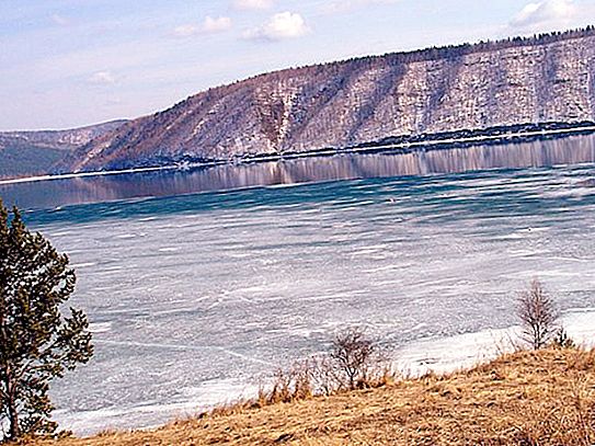
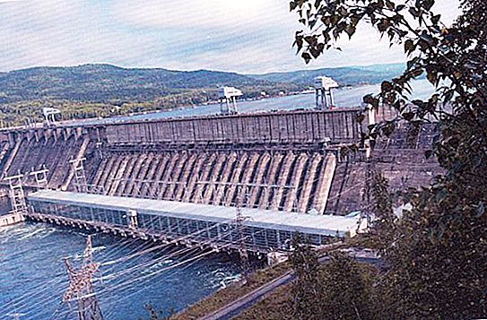
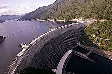
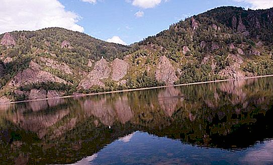
This site begins where the source of the Yenisei River. The Upper Yenisei (the local name of the river is Ulug-Khem) accounts for 600 km. It ends at the confluence of the Abakan River with a height mark of 243.6 m. The height of the source of the Yenisei River is 619.5 m. On a site 188 km long, the channel width is from 100 to 650 m with depths of at least 4 to 12 m, up to 1 m at rifts. The current velocity in rapids is 8 m / s, the average speed in summer is 2-2.5 m / s. Then, a 290 km long reservoir begins, formed by a dam blocking the Sayano-Shushenskaya hydroelectric power station with a height of 236 m. A few kilometers from it is a small reservoir of the Mainskaya hydroelectric power station, 21.5 km long.
The fall of the Upper Yenisei is 375.9 m. The averaged slope is 0.63 m per kilometer of the channel. The values of such slopes are characteristic of mountain rivers, which corresponds to the terrain conditions (Sayan Canyon, northern side of the Tuva Basin, rapids, high flow rate).
Middle Yenisei
The beginning of the middle part of the Yenisei consider the confluence of the river. Abakan - 2887 km from the mouth with a mark of 243.6 m. The river gradually loses signs of a mountainous character. The valley becomes wide (up to 5 km), the flow velocity decreases to 1-2 m / s in a channel with a width of 500 m.
The middle Yenisei begins with the Krasnoyarsk reservoir, the length of which is 388 km with an average width of 15 km. The lower boundary of the artificial reservoir above the city of Krasnoyarsk.
The Middle Yenisei ends at the confluence of the Angara River at 2137 km from the mouth with a height mark of 79 m. Between Krasnoyarsk and Strelka (a settlement near the mouth of the Angara), the Yenisei is up to 1300 m wide, and the flow slows down to 0.8 m / s.
The length of the Middle Yenisei is 750 km. The slope of the site with a total drop of 164.9 m is 0.22 m - with each kilometer of advance north to the Kara Sea, the channel "falls" by 22 cm.
Lower Yenisei
This is the longest stretch of 2137 km long - from the confluence of the Angara to the mouth of the Yenisei in the Sopochnaya Karga alignment. After the confluence of the Lower Tunguska, the channel becomes wide, reaching 5 km. The flow slows down to 0.2 m / s. In the estuary, the river is divided into 4 main channels, each of which is called the Yenisei, but is supplemented by the definition: Okhotsky, Kamenny, Bolshoi and Malyi. The total width of the channels is 50 km. Between the channels are the vast Brekhov Islands, rounding which they join again in one channel, forming the Yenisei Gulf at the very outskirts of the Kara Sea. The river has flat features: a slope of not more than 0.04 (up to 4 cm per kilometer), the flow velocity is almost imperceptible, surge phenomena are often observed - the flow of water from the sea to the bay.
River hydrology
The food of the Yenisei is mixed, consisting of half snow. The share of rainfall is 35%, groundwater in the upper reaches contributes 15%; downstream, their participation in the river’s nutrition decreases.
Ledostavit, the harbingers of which are intra-sea ice and autumn ice drift, begins from the lower reaches in early October, in the middle reaches it is mid-November, in the upper reaches - the end of November - December. Winter runoff is sharply reduced.
Spring flood stretches, starting on the middle Yenisei from the end of April. In the upper reaches, it begins a little later. In the lower reaches - from mid-May to the first decade of June. During ice drift, traffic jams form. Raising levels to 7 m in extensions and up to 16 m in channel narrowing. In the lower reaches, the level is higher - up to 28 m (Kureyka), but decreases to 12 m towards the estuary.


