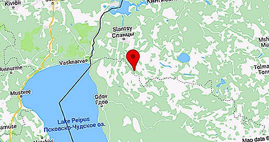
Plyussa is a small, but very picturesque river in the European part of Russia, flowing through the territories of the Pskov and Leningrad regions. The total length of its channel is 281 kilometers, and the catchment area is 6, 550 km 2. The Plyussa River is the right tributary of Narva, which forms the reservoir of the same name.
The name of the river comes from the Baltic "plus", which literally means "sedge".
General characteristics and photos of the river Plyussa
The source of the river is Zaplyussky lakes located on the border of the Pskov and Novgorod regions. The formation of these reservoirs led to human activities. Previously, Zaplyusskoye Lake was located at this place, which gave rise to the riverbed. As a result of reclamation work, one large reservoir broke into several small ones.
The mouth of Plyussa is the place where it flows into the Narva Reservoir, built on the Narva River and located north of the city of Slantsy on the Russian border with Estonia. The reservoir was created in 1956. Until this moment, Plyussa flowed directly into Narva. Thus, both the source and the mouth were greatly changed as a result of human actions.
In the Pskov region, the Plyussa River flows first in a westerly direction, and at the village of Dobruchi, it replaces it in a northward direction. Throughout the channel has a sinuous character.
The river basin forms many lakes, among which the largest:
- Black;
- Overseas;
- Long;
- Zaplusskoe;
- Shchirskoe;
- The song.
The river is replenished with multiple tributaries (more than 30), among which Yan and Luta are leaders in terms of average water discharge and catchment area, and Luta and Kureya are leading in length.
All ponds flowing into Plyussa are very small, like the river itself, which cannot boast of either breadth or great depths. Nevertheless, among the tributaries of Narva, this is the largest.
The Plyussa River is very popular among tourists due to its picturesqueness and high fishiness. Navigation in the flood is possible below 83 kilometers from the mouth (the village of Cherenovo), and at low water - on the segment between the settlements of Ivangorod and Slantsy.
The ecological situation on the river is not very favorable. Its waters are classified as slightly polluted, and in areas below cities - polluted.
Channel
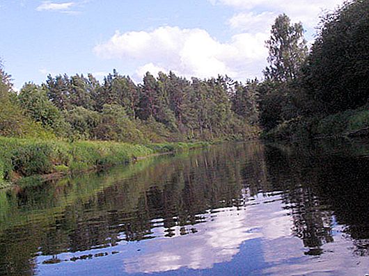
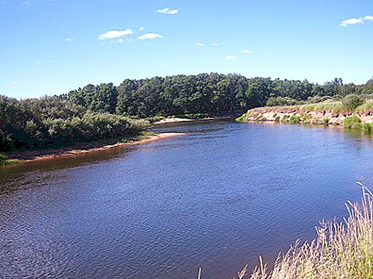
The Plyussa River has a narrow and shallow winding channel with a slope of 0.14%. The nature of the coast changes along the course. In the upper and middle parts of the river they are high, steep and dry, and in the lower reaches - in some places swampy.
The width and depth of the channel in different parts of Plyussa is not the same, and therefore several indicative segments can be distinguished in its course.
| River section | Width m | Depth, m |
| District (settlement) | 5 | 1 |
| Down from Small Lizi Village | 25 | 1, 5 |
| Plyussa Village | 40 | 1.7 |
| Near the village of Vir (towards the source) | 25 | 0.8 |
| Downstream from the village of Chernevo | 50 | 4 |
| Between the Pskov and Leningrad Regions | 70 | 2, 8 |
In some places, fords are found throughout the river. The bottom soil of Plyussa can be sandy, hard or muddy. In the area of shales, the channel crosses the ancient moraines, acquiring rapids.
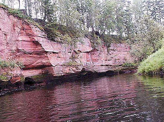
The shores are higher in the upper reaches, and in some places are represented by picturesque rocky sandstones, approaching the water very close.
Hydrology
The Plyussa River is characterized by mixed nutrition, to which the melting of the snow makes the greatest contribution. The total flow is 1, 461 km 3 / year, and the average annual water discharge is 46.3 m 3 / s. The flow rate varies from 0.1 to 0.3 m / s. The maximum flow rate at Plyussa is 774 m 3 / s, and the minimum is 8.05 m 3 / s. In the Shale area, this value is 50 m 3 / s.
High water occurs in the spring, accompanied by a rise in the river level by 6-7 meters. At this time, the width of the channel greatly increases. Rain floods lead to a rise in the level of the river by 2 m, and the formation of ice jams - by 1.8 m.
Freeze-up begins in the second or third months of winter, and ice drift begins in the transitional period from March to April.


